McAllister Tool & Machine Calls on Southern Radar Imaging's Locating Services for Help
The McAllister Tool & Machine Company in Huntsville, Alabama was suffering from a water drainage problem in their newly laid parking lot. To remedy the problem, they cut away some sections of the lot only to discover that the thickness of the asphalt varied in some spots. Ideally the asphalt’s thickness should be consistently two inches throughout its coverage. McAllister wanted to fix this problem before the asphalt contractor left so they recruited the help of Southern Radar Imaging. Southern Radar Imaging came in with an SIR 3000 ground penetrating radar and a 1500 MHz antennae (designed for shallow depths and high resolution). They scanned the entire lot, looking for variations within a six inch gravel base layer and a two inch asphalt top layer. The entire scan, processing, and reporting took about a day and a half. SRI identified two spots in the new asphalt that were thinner than the standard two inch thickness. McAllister’s asphalt contractor was then able to fix these spots ensuring that the entire lot was of even thickness, meeting standards and requirements. McAllister was very happy with Southern Radar Imaging’s results. This was a time sensitive issue needing to be resolved before the contractor could leave the job site. Southern Radar Imaging was quick to respond and quick to get the job done, all while supplying McAllister with an accurate scan and report.
 Matthew Wilbanks
in Recent Projects
|
Matthew Wilbanks
in Recent Projects
|
 Post a Comment
|
Post a Comment
|
 113 References
|
113 References
|  Email
|
Email
|  Print
Print
Bridge Deck Assessment & Scan - Alamaba Department of Transportation
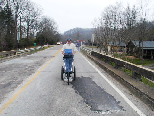
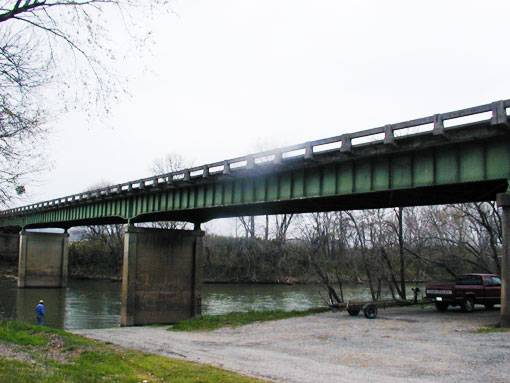
Southern Radar Imaging was recently contacted by the Alabama Department of Transportation concerning a deteriorating bridge deck. Build in 1949, the Elkmont, Alabama bridge is in need of repairs and in order for the Alabama DOT to get a better understanding of where the repairs will be most needed, project manager Matthew Willbanks of Southern Radar Imaging was called in to perform a thorough bridge scan.
Mr. Willbanks performed the scan and bridge assessment to get an idea of how much of the bridge’s concrete had been delaminated over the years. Southern Radar Imaging performed the scan in about two days and provided Alabama Department of Transportation manager Sean Butler with imaging scans and a full assessment report in about 3 business days.
Based on Southern Radar Imaging’s scan, a whole deck replacement of the bridge is possible but the repairs will more likely entail a partial deck removal, removing the bad concrete, and laying down an overlay.
Sean Butler of the AL DOT stated he was very happy with the results,
“I think Southern Radar Imaging is highly professional. They provided us with everything we needed and got the job done quickly…for what we had, if the situation arose again we would definitely use Southern Radar Imaging again in the future.”
To learn more about Southern Radar's services or to get in touch, feel free to contact them via their website or call 256-412-3287
Matthew Wilbanks
in Recent Projects
|
Post a Comment
|
70 References
| Email
| Print
Southern Radar Imaging Contracted for the New Bridge Street Town Centre Development in Huntsville, Alabama
The Bridge Street Town Centre in Huntsvillie, Alabama is a multi-million dollar, mixed-use lifestyle development that’s to be the hottest shopping center to be constructed in recent years. The new shopping center boasts over 70 upscale retailers and restaurants, including the 210-room Westin Huntsville hotel which includes 74 residential luxury condos. The property will also contain a new fourteen screen Monaco theater and a six-story office building. Aesthetic amenities such as a 10 acre lake with water craft rentals and green open park spaces are all set for a completion date around March of 2008.
A 550,000 square foot development project is no small matter and every structural detail must be inspected to preserve integrity for years to come. The Bridge Street Town Centre and the general contractors involved with the project needed the professional and expert assistance of the Southern Radar Imaging team (Kevin Jones, Matthew and Jason Willbanks) to perform radar imaging scans on the parking deck, restaurants, and Westin hotel. Southern Radar Imaging’s task was to locate all the post tension cables embedded within the concrete slabs of the development. The general contractors on the job had to run plumbing, electrical wiring, and fire safety sprinkler systems through the concrete slabs but had to be careful not the sever the tension cables to preserve the development’s foundation.
Southern Radar Imaging was called in to map all the post tension cables helping to guide the general contractors with various conduit installations. Southern Radar Imaging used a structure scan ground penetrating radar system with a 1500 MHz antenna to locate the cables which was the same system they successfully used on the Snow Shoe project in West Virginia.
Southern Radar Imaging’s Project Manager Matthew Willbanks states,
“we saved them a lot of time and money so everybody was happy with the project. We were called out several times by various contractors to perform scans on the site. We pretty much worked for every contractor involved with the project… throughout the project the need would arise to be on site as soon as possible and we would always arrive within 24 hours.”
Scanning a new development to preserve structural integrity is a time and money-saving preventative must. The Southern Radar Imaging team always seems to surpass expectations completing projects quickly, efficiently, and effectively.
Matthew Wilbanks
in Recent Projects
|
Post a Comment
|
165 References
| Email
| Print
Tennessee Valley Authority Hires Southern Radar Imaging for Rebar Location Project
Tennessee Valley Authority is the nation’s largest public power company. TVA had started a project to install a new oil and water separating system within their Wheeler Dam plant in Northern Alabama . In order to install the pipe hangers inside the hydro-electric facility, holes were drilled into the concrete about an inch in diameter near the existing pipe gallery. While drilling, TVA would often accidentally hit the rebar embedded within the concrete. Puncturing the rebar could compromise the structural integrity of the facility and this had to be avoided. TVA called-in Southern Radar Imaging to help locate the embedded rebar and guide the drilling.
Southern Radar Imaging received the call for the job on Wednesday, September 26th. They were on the job the very next day and completed work that Friday. Southern Radar Imaging used the radar detection assistance of an SRI 3000, 1500 MHz antenna which they pulled across the concrete walls to locate the precise location of the rebar. Southern Radar Imaging’s efforts minimized the pipe gallery’s installation time by taking the guesswork out of the drilling process.
For TVA this was a time sensitive project that was expedited with the help of Southern Radar Imaging. TVA needed to get this completed before the end of the fiscal year and SRI delivered thanks to Southern Radar Imaging's own Mattew Wilbanks and Kevin Jones.
Matthew Wilbanks
in Recent Projects
|
Post a Comment
|
22 References
| Email
| Print
Snow Shoe Mountain Condo Developer Hires Southern Radar Imaging for Indoor Inclusion Location Survey
Southern Radar Imaging, A ground penetrating radar and inclusion location service out of Athens, Alabama was recently hired by major condo developer Intrawest Placemaking. Intrawest has recently built new condo developments on the summit of Snow Shoe Mountain in Snow Shoe, West Virginia. Intrawest was in immediate need of radar detection services to locate rebar and conduit in the concrete slab of their newly constructed park structure.
Matthew Willbanks, business developer and project manager for Southern Radar Imaging was contacted by the principal engineer of the Snow Shoe project. The engineer needed the services of Southern Radar Imaging for an immediate survey. Matthew states…
“It was kind of hectic. I went from finding out about the job on a Wednesday morning, talked to the project manager from Snow Shoe, flew up Wednesday evening to look at the job and had a proposal to them by Thursday. We went to work for them on Monday. They needed the work fast and we got it to them.”
The Intrawest job consisted of scanning 3500 square feet of twelve inch concrete slab using a 1500 MHz indoor antennae. Intrawest Placemaking needed to avoid disturbing the previously set inclusions to maintain the structural integrity of their new development when making alterations to the concrete slab. Southern Radar Imaging scanned the slab and found rebar or conduit inclusions. Southern Raadar Imaging then marked the concrete in real-time. Southern Radar Imaging completed the first phase in 18 days, three days ahead of the set completion date.
“Intrawest was very happy with the work we performed in phase one and we’ll be coming back to Snow Shoe in early 2008 to complete phase two.”
Southern Radar Imaging has been in business since May of 2006 and has been rapidly growing. Southern Radar Imaging performs indoor and outdoor inclusion location services, bridge assessments, locating underground utilities, archaeological projects, and natural 3D geology imaging.
Matthew Wilbanks
in Recent Projects
|
Post a Comment
|
48 References
| Email
| Print