What is (GPR) Ground Penetrating Radar?
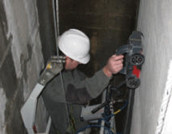 GPR is an abbreviation for Ground Penetrating Radar. GPR is a non-destructive electromagnetic surveying method first used for geological research in 1929. Since then, the uses of GPR have vastly expanded. While still used for geology, GPR is now used for archaeology, forensics, construction, roadway and bridge evaluation, environmental testing, and unexploded ordinance (mines) location. The technique consists of sending an electromagnetic signal into the surface being surveyed with one antenna, receiving any signal that returns with another (or the same) antenna, and then processing the received signals into an image. The operator then has the task of interpreting the images. With both 2-D and 3-D imaging capability, we can provide full reports of the survey results.
The signal we get back reflects the electrical and magnetic properties of the subsurface we are surveying. Whether metal, cement, clay, bedrock, or other, every material has its own electromagnetic properties. When these properties are dissimilar enough, such as metal and cement, we can image them as separate objects. Even rock and sediment layers that are different enough can be distinguished.
GPR is fast, safe, portable, non-destructive, and has the highest resolution of any subsurface surveying method.